The mysterious and unexplored North eastern region of India,is the eastern-most region of India. It is connected to East India via a narrow corridor squeezed between independent nations of Bhutan and Bangladesh. It comprises the contiguous Seven Sister States (Arunachal Pradesh, Assam, Manipur, Meghalaya, Mizoram, Nagaland, and Tripura), plus the Himalayan state of Sikkim. Except for the Goalpara region of Assam, the rest did not become part of political India until the 19th century and later. The Brahmaputra valley area of Assam became a part of British India in 1824, with the hill regions annexed later. Sikkim was annexed to the Indian union through a referendum in 1975; it was recognized as part of Northeast India in the 1990s.
The location of the region is strategically important as it has international borders with Bangladesh, Bhutan, China, Myanmar and Tibet. The area is characterized by rich bio-diversity, heavy precipitation and high seismicity. It is endowed with forest wealth and is ideally suited to produce a whole range of plantation crops, spices, fruits and vegetables and flowers and herbs. The rich natural beauty, serenity and exotic flora and fauna of the area are invaluable resources for the development of eco-tourism. Total area of the region is about 2,55,168 Sq. Km. All the seven states are members of the North East Council, organised on 1st August 1972 and within the Jurisdiction of Guwahati High Court.
After Indian Independence from British Rule in 1947, the Northeastern region of British India consisted of Assam and the princely states of Manipur and Tripura. Subsequently, Nagaland in 1963, Meghalaya in 1972, Arunachal Pradesh in 1975 (Capital changed to Itanagar) (formed on 20 February 1987) and Mizoram in 1987 were formed out of the large territory of Assam.[16] Manipur and Tripura remained as Union Territories of India between 1956 until 1972, when they attained fully-fledged statehood. Sikkim was integrated as the eighth North Eastern Council state in 2002.[17]The city of Shillong served as the capital of the Assam province created during the British Rule
The region has a high concentration of tribal population. The states of Arunachal Pradesh, Meghalaya, Mizoram and Nagaland are mostly inhabited by a number of native tribes. Each tribe has its own distinct tradition of art, culture, dance, music and life styles. The numerous fairs and festivals celebrated by these communities and their friendly nature are irresistible attractions for the visitors.
• 51 forest types are found in the region, broadly classified into six major types — tropical moist deciduous forests, tropical semi evergreen forests, tropical wet evergreen forests, subtropical forests, temperate forests and alpine forests.
• Out of the nine important vegetation types of India, six are found in the North Eastern region.
• These forests harbour 8,000 out of 15,000 species of flowering plants. In floral species richness, the highest diversity is reported from the states of Arunachal Pradesh (5000 species) and Sikkim (4500 species) amongst the North Eastern States.
• According to the Indian Red Data Book, published by the Botanical Survey of India, 10 percent of the flowering plants in the country are endangered. Of the 1500 endangered floral species, 800 are reported from North East India.
• Most of the North Eastern states have more than 60% of their area under forest cover, a minimum suggested coverage for the hill states in the country in order to protect from erosion.
• North East India is a part of Indo-Burma 'hotspot'. The hotspot is the world's second largest, next only to the Mediterranean basin, with an area 2,206,000 square kilometres (852,000 sq mi) among the 25 identifie
It is a Unique Region for Nature Lovers..The International Council for Bird Preservation, UK identified the Assam plains and the Eastern Himalaya as an Endemic Bird Area (EBA). The EBA has an area of 220,000 km2 following the Himalayan range in the countries of Bangladesh, Bhutan, China, Nepal, Myanmar and the Indian states of Sikkim, northern West Bengal, Arunachal Pradesh, southern Assam, Nagaland, Manipur, Meghalaya and Mizoram. Because of a southward occurrence of this mountain range in comparison to other Himalayan ranges, this region has a distinctly different climate, with warmer mean temperatures and fewer days with frost, and much higher rainfall. This has resulted in the occurrence of a rich array of restricted-range bird species. More than two critically endangered species, three endangered species, and 14 vulnerable species of birds are in this EBA. Stattersfield et al. (1998) identified 22 restricted range species, out of which 19 are confined to this region and the remaining three are present in other endemic and secondary areas. Eleven of the 22 restricted-range species found in this region are considered as threatened (Birdlife International 2001), a number greater than in any other EBA of India.
Assam is one of the most advanced state of Northeast, is blessed with vast alluvialm plains rich in forests and rolling tracts of paddy and tea, and oil from the vast depths of the earth... assam was ruled for 6 centuries by the brave Ahoms from 13th century you can still see some of their places , tanks and temples around sivasagar. renowned, Kaziranga, Manas National park, world largest river island Majuli are in Assam.
Assam is a northeastern state of India with its capital at Dispur. Located just below the eastern Himalayan foothills, it is surrounded by the other northeastern states: Arunachal Pradesh, Nagaland, Manipur, Mizoram, Tripura and Meghalaya. Assam and its commercial capital Guwahati form the gateway to the northeastern states, together called the 'seven sisters'. These states are connected to the rest of India via Assam's border with West Bengal and a narrow strip called the "Chicken's Neck." Assam also shares international borders with Bhutan and Bangladesh. Situated between 90-96 degree East Longitute and 24-28 degree North Latitude, Assam is very rich in vegetation, forests and wildlife. The region also has a number of reserved forests, and one of them, Kaziranga, is the home of the rare Indian Rhinoceros. High rainfall, deforestation, and other factors have resulted in annual floods that cause widespread loss of life, livelihood and property. An earthquake prone region, Assam has experienced two large earthquakes in 1897 and 1950.
How to reach
No permit is required by domestic as well as foreign tourists to visit Assam. However, foreign tourists must have an Indian Visa.
By Road
A network of National Highways and other roads connect all important places of Assam. All the towns of Assam are well connected by the Assam State Transport Corporation and other tourist bus services run by private operators.
History
Assam was known as 'Kamarupa' or 'Pragjyotish' in the period of the Epics. Human inhabitation of this area dates backs to about 2000 BC. The population of Assam comprises of the migrants from Burma and China. They came into Assam after the mongoloid migration. They came from Punjab through Bihar and North Bengal. Thus Assam presents a fusion of Mongol-Aryan culture. The early history of Assam is believed to be of the Varman dynasty. The reign of this dynasty extended from 400 AD to 13th century. The visit of Huien Tsang is said to have taken place during the 7th century at the time of Kumar Bhaskar Varman. The Ahoms ventured into Assam in about 1228 AD. By 15th century the kingdoms of Ahom and Koch were established. This period witnessed a change in all walks of life in Assam. In the later part of the 18th century the Ahom Kingdom was weakened due to internal strife. The Burmese ran over the political authority in Assam thus invoking British intervention to subdue the Burmese. After a conflict between the Burmese and the English, peace was restored by the treaty of Yandaboo in 1826. The British then set out to organize the administration, transport and communication. Besides the various changes, the construction of railways; introduction of tea plantation, discovery of coal and oil etc. proved fruitful to the British during the World War II. After Independence of India, Assam witnessed several separation of territories. In 1948, NEFA (Arunachal Pradesh) was separated. In 1963 Nagaland was separated. In 1972 Meghalaya and in 1987 Mizoram.
T-shaped, the state consists of the northern Brahmaputra valley, the middle Karbi and Cachar hills and the southern Barak Valley. It experiences heavy rainfall between March and September, with very high humidity in the summer months. The temperatures are generally mild, never extreme during any season. Summer is from March to June and monsoon from July to August. November to February is winter. Best season to visit Assam is February to May.
Population
The 1991 Census puts the population of Assam at 2,24,14,322 with a sex ratio of 896 females per 1,000 males and a growth rate of +53.26 per cent in the two decades from 1971 to 1991. There are 16 Scheduled Castes and 23 Scheduled Tribes constituting 7.40 and 12.82 per cent respectively of the State's population.
Languages
Assam is a multiethnic society. Forty five different languages are spoken by different communities in Assam. The state is the meeting place of three major language families: Austroasiatic (5), Sino-Tibetan (24) and Indo-European (12). Three of the spoken languages do not fall in these families. There is a high degree of bilingualism.
Assamese and Bodo are the official languages of the state. Linguistically modern Assamese traces its roots to eastern Magadhan Prakrit, with strong influences from the Tibeto-Burman and Mon-Khmer languages which are spoken by indegenous ethnic groups in the region. Bodo is a Tibeto-Burman language. Bengali is the second most spoken language in the state, and the predominant language in the Barak Valley, the largest city of which is Silchar.
Culture
Assamese culture is a rich conglomerate of ethnic practices and assimilated beliefs. When the Tai Ahoms entered the region in 1228, they had their own cultural features. Over the six centuries of their rule, they adopted the local language, religion and cultural customs, and embellished it with their own to such an extent that it puts them apart from medieval rulers of India. This is one reason why Assamese culture is so rich in heritage and values.
Agriculture
Agriculture is the main occupation of the people and along with the allied occupations it accounts for 63 percent of the states work force. Rice is the staple diet of the people and cultivation of rice is the main occupation of those engaged in agriculture. Different pulses, jute, tea and fruit cultivation are the other agricultural crops. Sugarcane, potatoes, cotton, oil seeds, coconut and arecanut cultivation is also practiced on a substantial scale apart from the horticulture. But 67 percent of the gross cropped area is taken up by rice cultivation, of this about 67 percent again is taken up for the cultivation of Sali paddy on about 16-17 lakh hectares of land. Both the centre and the state are engaged in giving agriculture a big thrust and a second green revolution is to be brought about in the north east. Jhum cultivation or shifting cultivation, under which the tribal farmers burn selected areas of forest land and use it for cultivation in a cyclic period, is a problem in Assam. Confined to its two hill districts which are inhabited by tribal people, efforts are being constantly made to wean the people away from this rather expensive form of cultivation.
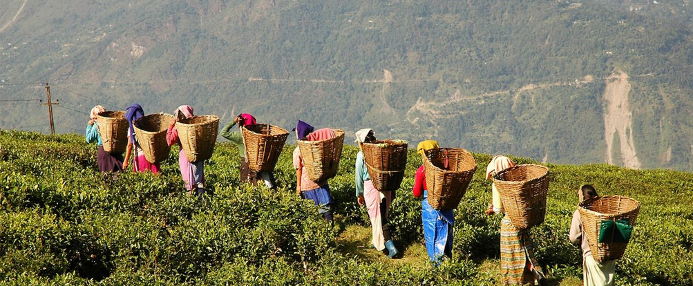
Among fruit crops, Assam has oranges and other citrus fruit, bananas, guavas, pineapples and mangoes. There are extensive plans to expand the cultivation of these fruit products and market them to bring greater benefits to the farmers. The gross cropped area in the state is about 35 lakh hectares out of which rice cultivation alone accounts for 26 lakhs. Forests are an important part of Assam's economy. Timber is a major product of the states extensive forests and bamboo is another product, bringing Assam substantial revenue and adding to its wealth. Assam is rightly known for its excellent tea which is one of the major cash crops . About 15 percent of the world's total output of tea comes from the tea gardens of Assam, which provide employment to more than a million people. More than half of that in direct form in the tea gardens and factories turning green leaves into dry tea for home and hotel consumption. Tea cultivation occupies a little less than a tenth of the cultivated area of Assam and 75 percent of the tea gardens are located in the Brahmaputra districts of Darrang, Sibsagar and Lakhimpur. Cachar district accounts for 20 percent of the balance and the remaining 5 percent being accounted by the lower Brahmaputra valley. Guwahati centre in Assam has become the biggest centre of auction of CTC tea in the world.
Industry
Assam is an important producer of silk of different kinds and known for weaving of silk products into saris and fabrics. Production of tusser and other silks and weaving of fabrics is an important occupation for a number of people. Other types of industries are food products, wood and wood products, chemicals and chemical products, non-metallic mineral products. Tea and oil are of prime importance to Assam's economy and also plays a significant role in the economy and life of the state. At Digboy on the border with Burma, Assam has the oldest Indian oil venture and one of the oldest in the world.
Minerals
Assam is endowed with vast mineral resources. The major minerals like coal, oil and gas, limestone, dolomite, sillimanite and corundum, iron ore, felspar, glass-sand, refractory and fire clays, kaolin, beryl, gypsum, pyrite, vermiculite, salt, copper, gold etc. have been reported to occur in the state. The most important minerals being exploited so far in Assam are coal, oil and gas, limestone and sillimanite.
Coal
Assam coal is being consumed at present by the railways, iron and brass foundries, brick kilns, inland water steamer services, tea gardens and other industries in addition to household consumption. Apart from its general uses, Assam coal is eminently suitable for the manufacture of coal distillation products.
Oil and Natural Gas
The oil producing areas of Assam lie in the upper Assam valley and are geologically confined to the Tertiary Strata - mainly Oligocene. Assam is first state in the country where oil was struck in 1889 at Digboy. At present oil is being tapped at two areas - the Digboy and the Naharkotiya and Moran fields. Two more refineries of considerable size have come up in the public sector at Gauhati and Barauni and the third with a petrochemical complex is under way. A new refinery, Numaligarh refinery (3m. tones capacity) was commissioned on July 9, 1999. The availability of associated natural gas is dependent on the extraction of crude oil. Vast quantities of natural gas are being produced along with the production of crude oil. Only two projects under the "utilization of natural gas scheme" have so far come up in the state. These are the thermal power plant and the fertilizer factory at Namrup.
Limestone
The high-grade fossil limestone or 'nummulitic' limestone deposits of Assam are geologically known as 'Syket limestone' as these belong to that groups of rocks. The limestone deposits are confined in areas of Garo hills, united Khasi and Jaintia hills, Cachar hills and Mikir hills. One of the largest outcrops of limestone is at the foot of the Khasi hills. Vast deposits of high-grade limestone are best observed in the Jowai area. Lime stones of the Khasi and Jaintia hills can be used for manufacture of cement and for lime-burning purposes. It can be used in chemical industries and for metallurgical purposes. The limestone deposits of the state offer vast scope for developing innumerable industries where limestone is required.
Sillimanite
The sillimanite deposits of the Nongstoin state in the Khasi hills are world famous from the point of view of quantity and purity of the mineral. Assam is the major producer of this mineral in India and contributes more than 90% of the total production. Corundum is found to occur in association with the sillimanite deposits. Low-grade 'quartz-sillimanite schists' also occur in the same area.
Clay
Assam is endowed with fairly large reserves of sedimentary white clays as well as Kaolin or 'China clay', which forms an important basic raw material for ceramic or refractory industries. These Clays are found to occur at many places in the Garo hills, Khasi and Jaintia hills and the Mikir hills. This clay is quite suitable for the manufacture of medium to low-grade white wares and other ceramic products like stoneware pipes, sanitary ware, glazed tiles and bricks. The Kaolin deposit near Mawphlang is found to be as good as the Kaolin of corn wall.
Glass Sands
Deposits of fine-grained, white friable sandstones has been located in the coalfields of the Laitryngew and Cherapunji areas. The friable quartzite of the Shilllong series around shillong and the Tura sandstones of the Garo hills are suitable for manufacture of sheet glass and fruit glass after washing.
Iron Ore
Occurrence of banded-iron ore have been located in the Chanderdinga hills and Abhayapuri areas in Goalpara district and in the Aradanga-Rangchapara areas on the border of the Kamrup and Khasi and Jaintia hills districts
Copper
Copper minerals occur in the Umpyrtha and Ranighat areas in the Khasi and Jaintia hills and also in the Mahamaya hills in Goalpara district.
Felspar
Felspar is a common mineral found to occur in association with granites. Recently workable felspar deposits have been recorded near the Hahim area in Kamrup district.
Gold
Gold is reported to occur in sands, gravels and alluvial terraces along some of the rivers in the Lakhimpur, Sibsagar and Darrang districts of Assam.
A gold-bearing rock was located at a place about 5 miles southwest of Mawphlang.
Gypsum
Gypsum in the form of selenite crystals and disseminated in shale beds occur at Mahendraganj in the Garo hills and at a few places in the Mikir hills.
Adventurous Activities
Angling
The river Jia Bhoroli, Kapili and Manas are the best places for angling. The Jia Bhoroli river is home to the fierce game fish, the Golden Mahseer, or tiger of the Himalayan rivers. Famous for its golden Mahseer, an annual Angling competition is held regularly at Jia Bharali where a number of anglers both from outside the state as well as abroad participate every year. Angling is so popular a sport here that there is an organised body by the name 'Assam Bhoroli Anglers Association' which organises this sport in the month of November every year in collaboration with the State Forest Department.
Camping
Eco Camp, Situated in the fringes of Nameri National Park is an ideal camping site with all modern amenitites
River Cruise
The turbulent rivers, the mystic blue hills, the savage terrains and serene countryside beckon the adventurers to Assam. Challenge the Brahmaputra, one of the four largest rivers in the world and cruise down the mystic river from Ninging to Dhubri.
Boat Racing
Boat racing is a very popular sport of the state. People very often organise boat racing during festive occasions at places like Hajo, Saulkuchi, Barpeta, Guwahati etc. The involvement of the masses in this sport can be compared with the snake-boat racing in Kerala.
River Rafting
The mighty river Brahmaputra and its turbulent tributaries like Manas, Jia Bhoroli and Kapili offer immense scope for River Rafting. The fiery rapids in these rivers fuel the spirit of adventure in you.
Golf
Most of the tea gardens of Assam have golf courses attached to them. All of them are 9 hole golf courses except for Digboi which is an eighteen hole course. Assam has 21 golf courses. Most of these are run by the tea estates and have air strips attached to them.
A stay in the tea garden, playing golf and driving through tea country is an unforgettable experience.
Mountaineering & Trekking
Assam's topography makes her an ideal destination for trekkers, mountaineers and rock climbers. The hills, in particular, the North Cachar Hills and Karbi Hills are ready to receive tourists for trekking and mountaineering. There is a recognized trekking route in both the districts. There is also a rock hill in Morigaon District known as "Elephant Rocks" which offer ample scope for Rock Climbing. The Simhasana Hill of Karbi Anglong is also famous for rock climbing. The main city of Assam, Guwahati, is surrounded on three sides with beautiful hills.
Mountain Biking
The hilly terrain offers a very good challenge to Mountains Bikers. The Assam Tourism Department in collaboration with The Assam Tourism Development Corporation and other adventure organizations have organized several bicycle and motorbike rallies in and outside the state. Several foreign groups including individual tourists have visited the state for the same.
Para-Sailing
A totally new sport, Para-sailing, has been introduced by Assam Tourist Development Corporation to attract domestic and foreign tourists. The ideal place for Para-sailing near Guwahati is North Guwahati.
Hang Gliding
Hang Gliding also has potential here. The ideal place for Hang Gliding are Kamakhya Hills and hills around Kaziranga.
The land of the blue mounttain, neighbours Manipur, assam,And tripura but a part of it slips down between Myanmar and bangladesh... accrding to histry of Mizoram, Mizo people migrating from their homeland in china 3 centuries ago in search of new pastureland,settledin this remote Mizo hills(lusai Hills).
HISTORICAL BACKDROP : The origin of the Mizos, like those of many other tribes in the North Eastern India is shrouded in mystery. The generally accepted as part of a great Mongoloid wave of migration from China and later moved out to India to their present habitat.
It is possible that the Mizos came from Shinlung or Chhinlungsan located on the banks of the river Yalung in China. They first settled in the Shan State and moved on to Kabaw Valley to Khampat and then to the Chin Hills in the middle of the 16th century.
The earliest Mizos who migrated to India were known as Kukis, the second batch of immigrants were called New Kukis. The Lushais were the last of the Mizo tribes migrate to India. The Mizo history in the 18th and 19th Century is marked by many instances of tribal raids and retaliatory expeditions of security. Mizo Hills were formally declared as part of the British-India by a proclamation in 1895. North and south hills were united into Lushai Hills district in 1898 with Aizawl as its headquarters
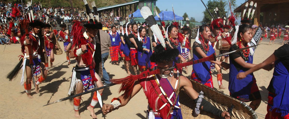
The Land of Myths and fesivals, and brave warriors and the tribal richness, Nagaland lures the adventurous of heart. its colouefull people great verdant landscapes and cultural strengths are a delightfull combination for a holiday experience..
Nagaland is a vibrant hill state Located in the extreme North Eastern End of India, bounded by M yanmar in the East; A ssam in the West; Arunachal Pradesh and a part of A ssam in the North with Manipur in the south.It offers rich incomparable traditional and cultural heritage.
The Distinctive character and identify of each tribe in terms of Tradition, custom, language and dresses is clearly discernible to the visitors.
The respective tribal festivals are celebrated at interval all over the State.
The entire Konyak Community of Nagaland, observed Aoleong Monyu in the first week of Aoleong Lee (April) every year since time immemorial. Aoleang is observed after completion of sowing of seeds in the new fields and to marks the end of the old year and to welcome the new year beginning with spring when a riot of flowers in every hue start to bloom. It is time to ask Almighty God for beautiful harvest of crops in that very year. The Aoleang Monyu is spread over six days. Each day has separate names and different significance :
(1) Hoi Lai Yah Nyih
(2) Yin Mok Pho Nyih
(3) Yin Mok Shek Nyih
(4) Lingnyu Nyih
(5) Lingha Nyih and
(6) Lingshan Nyih.
NAGALAND is a land of festivals. All the tribes celebrate their distinct seasonal festivals with a pageantry of colour and a feast of music.
All the tribes have their own festivals which they hold so dear. They regard their festivals sacrosanct and participation in celebration is compulsory. They celebrate their distinct seasonal festivals with a pageantry of coulour and a feast of music.
Most of these festivals revolve round agriculture, it being the main-stay of Naga society. Over 85% population of Nagaland is directly dependent on agriculture and lives in a thousand and odd villages situated on high hill tops or slopes overlooking verdant valleys humming with murmuring streams. In this blissful setting Nagas enjoy the blessing of Nature with rare gusto striking the onlookers with awe and admiration. In most of the places agriculture consists of monocrop .
The scotland of the east... Meghalaya Inhabited by the Khashi, jaintia, Garo tribes... it is best known for the preety hill station Shillong.. which has been Meghalayas first city for a long time..borderlines with Assam and Bangladesh..
The Khasi, Jaintia, Bhoi, War collectively known as the Hynniewtrep people predominantly inhabit the districts of East Meghalaya, also known to be one of the earliest ethnic group of settlers in the Indian sub-continent, belonging to the Proto Austroloid Monkhmer race.
The Garo Hills is predominantly inhabited by the Garos, belonging to the Bodo family of the Tibeto-Burman race, said to have migrated from Tibet. The Garos prefer to call themselves as Achiks and the land they inhabit as the Achik-land
Khasi Festival
The Khasis, Jaintias and Garos of Meghalaya celebrate several festivals which are directly and indirectly connected with religion. They are full of joy and happiness which is expressed outwardly in the form of dance, feast and worship.
Shad Suk Mynsiem Dance
In every religious ritual of Khasi tribe, the grand finale is the performance of a dance, a Thanks Giving Dance called 'Shad Phur', which is now called "Shad Suk Mynsiem." The religious rituals or ceremonies might concern certain families, clans, villages, raijs, or the state (Hima).
The Shad Suk Mynsiem reflects the matrilineal and patrilineal aspect of the Khasi society. The man with whips and swords circles the virgins, as protectors of the honors of womanhood having a single strength and resource while the men have in them twelve strength and resource. Shad Suk Mynsiem is celebrated in the month of April at the Weiking grounds near Shillong and at other places in Meghalaya.
Nongkrem Dance
To the first time visitor the experience of driving through undulating hills and narrow roads to Smit, where the famous Nongkrem Dance is held at the courtyard of the Syiem of Hima Khyriem (chief of Khyriem), is thrilling and full of fun. For the "serious traveler" and students of culture and history there is a lot to learn and store from this dance of the Khasi tribe which is held every year at Smit which is 15 Kilometers from Shillong.
It is one of the most important festivals of the Khasi tribe and is celebrated with pomp and gaiety. Hundreds of travelers from different parts of this country and from abroad come to witness the festival as is performed in the traditional style by the Syiem, the head of the Khasi state, and Ka Syiem Sad, the Syiem priestess, who is considered the caretaker of all religious ceremonies, the ministers and the common people. The fourth day of the festival is when most visitors throng to the courtyard to witness the dance performed by ladies and men decked in some of the most exquisite traditional attires. Young virgin girls wear expensive silk and gold ornaments dance the Ka Shad Kynthei in the inner circle of the arena, while men dressed in dhoti, full-sleeved shirt, sleeveless coat and a turban with sword in their right hand perform the Ka Shad Mastieh in the outer circle.
In Garo tribes, women are the owners of property thus making it a matrilineal society. There is a custom where the youngest daughter inherits the property from her mother and man shifts to his wife's place after getting married.
These tribes are also lovers of music and dance. They use various traditional musical instruments like stringed instruments, wind instruments and self sounding instruments. Men flaunt turban with clothes in villages. Whereas, blouse and a cloth tied around their waist is worn by Garo women. They also love to wear traditional jewellery made of beads and other material.
Garos also celebrate different festivals. Wangala is one of the significant festivals of these tribes which is generally celebrated in the month of October. This festival is celebrated after the harvest of crops as thanks giving ceremony to their deity Salijong. Rice is the staple food of Garos and most of them are non-vegetarians. They also make liquor at home from food grains. Their main cultivation crops include rice, ginger, millet, bananas, vegetables, pepper, chilli and cotton.
One of the oldest states of Northeast..Manipur Enjoys its own Individual Identity with vigorous enthusiasm.this is reflected the martial arts of Thang-ta and sarit-sarak. Its artistic learningare visible in its gracefull Ras leela dance form and intricate hand- woven swals. Manipur offeres visitors a comprehensive diversity of tourist delights.
Manipur literally meaning "A jeweled land" nestle deep within a lush green corner of North East India. It seems much like an exquisite work of art executed by superb hands of Nature and is indeed a state of exquisite natural beauty and splendors, the beauty of which once inspired Mrs. St. Clair Grimwood described it as " A Pretty Place more beautiful than many show places of the world" Late Pandit Jawaharlal Nehru paid a fitting tribute by describing it as "Jewel of India".
Surrounded by blue hills with an oval shaped valley at the centre, rich in art and tradition and surcharged with nature's pristine glory. Manipur lies on a melting pot of culture. It is birth place of Polo. This is the place where Rajashree Bhagyachandra created the famous Ras Lila, the classical dance of Manipur, out of his enchanting dream by the grace of Lord Krishna ,Her folk dances reveal the mythological concept of creation of Manipur
Festivals of Manipur
Manipur is a land of festivities. Merriments and mirth-making go on round the year. A year in Manipur represents a cycle of festivals. Hardly a month passes by without a festival which, to the Manipuris, is a symbol of their cultural, social and religious aspirations . It removes the monotony of life by providing physical diversions, mental recreation and emotional outlet, helps one to lead a more relaxed and fuller life.
Lai-Haraoba: - Celebrated in hour of the sylvan deities known as Umang Lai, the festival represents the worship of traditional deities and ancestors. A number of dances by both men and women are performed before the ancient divinities. The Lai Haraoba of God-Thangjing, the ruling deity of Moirang, is the most famous one and attracts huge gatherings. It is held in the month of May.
Yaoshang(Dol Jatra):- Celebrated for five days commencing from the full-moon day of Phalgun (February/March), Yaoshang is the premier festival of Manipur. The Thabal Chongba, a kind of Manipuri folk dance in which boys and girls hold hands and dance away their blues in festive tube-lit ambience is an inseparable part of the festival. Young and old folks collect donation from house to house and the money so collected is spent in parties and feasts. However, of late, time and energy earlier spent in this festival has been utilized in locally organized games and sports meets. Athletes got a shot in the arm, ever since
Ratha Jatra : One the greatest festivals of the Hindus of Manipur, the festival is celebrated for about 10 days in the month of Ingen (June/July). Lord Jaganath leaves his temple in a Rath locally known as Kang pulled by pilgrims who vie with one another for this honour.
KUT ( Festival of Kuki-Chin-Mizo):- It is an autumn festival of the different tribes of Kuki-Chin-Mizo groups of Manipur. The festival has been variously described at different places amongst different tribes as Chavang-Kut or Khodou etc. It is a happy occasion for the villagers whose food stock is bountiful after a year of hard labour. The festival is a thanks giving feasts with songs and dances in merriment and joviality for all, in honour of the giver of an abundant harvest, it is observed on the 1st of November every year
Gang-Ngai (Festival of Kabui Nagas) : Celebrated for five days in the month of Wakching (December/January) GANG-NGAI is an important festival of the Kabui Nagas. The festival opens with the omen taking ceremony on the first day and the rest of the days are associated with common feast, dances of old men and women and of boys and girls, presentation of farewell gifts etc. For 1997, it starts from Janaury 21.
Chumpha (Festival of Tangkhul Nagas):- Celebrated for seven days in the month of December, the Chumpha festival is a great festival of the Tangkhul Nagas. The festival is held after harvest. The last three days are devoted to social gatherings and rejoicing. Unlike other festivals women play a special role in the festival. The concluding part of the festival ends with a procession within the village.
When the sun first strikes India, it shines upon Arunachal's wild jungles and tribal communities. Arunachal, the name means " land of rising sun". Arunachal Pradesh is a sprawling mountainous territory, a land of mighty rocks and luxuriant forests, gentle streams and ragging torrents, presents a breath-taking spectacle of nature in all her glory, raw and unspoilt and untamed in wild profusion of flora and fauna, customs, language and dress.
It is said that one picture is equivalent to thousand words. This photo gallery presents a glimpse of Arunachal Pradesh and will surely create a bond of love with the visitors.
Largest of all the northeast states , AP is blessed by delightfully variegated climate - perfect for holidays any time of the year...Almost 80% of the state under forest cover. which varies from sub- tropical to the alpine in the upper regions of the northeast. where it is bordered by the Himalayan renges. shares borderline with China ( Tibet), Myanmar, And Bhutan. land of tribal people...
Arunachal Pradesh attained its statehood on 20th February 1987. It is situated in the North-Eastern part of India with 83743 sq. kms area and has a long international border with Bhutan to the west (160 km), China to the north and north-east (1,080 km) and Myanmar to the east (440 km). It stretches from snow-capped mountains in the north to the plains of Brahmaputra valley in the south. Arunachal is the largest state area-wise in the north-east region, even larger than Assam which is the most populous.
The widely scattered archeological remains at different places in Arunachal bears testimony to its rich cultural heritage. Arunachal Pradesh, a serene land tucked into the North Eastern tip of India, invites you to relax in its picturesque hills and valleys, enjoy its salubrious climate and meet its simple and hospitable people, with their glorious heritage of arts and crafts and colourful festivals that reflect their ancient faith in the inexorable power of nature.
The visitor has a wide variety of options to pick from. There are places of worship and piligrimage such as Parasuramkund and 400 years old Tawang Monastery, or the sites of archeological excavations like Malinithan and Itanagar, the serene beauty of lakes such as Ganga lake or Sela lake or the numerous variations of scenic beauty of the snowclad silver mountain peaks and lush green meadows where thousands of species of flora and fauna prosper. In addition, the state provides abundant scope for angling, boating, rafting, trekking and hiking. Besides, there are a number of wild life sanctuaries and national parks where rare animals, birds and plants will fascinate the visitor.
Nature has provided the people with a deep sense of beauty which finds delightful expression in their songs, dances and crafts. The climate varies from hot and humid to heavy rainfall in the Shivalik range. It becomes progressively cold as one moves northwards to higher altitudes. Trees of great size, plentiful climbers and abundance of cane and bamboo make Arunachal evergreen.
Arunachal Pradesh is considered to be the nature's treasure trove and home to orchids, known for their exquisitely beautiful blooms, from one of the dominant taxa with more than six hundred species, occurring in varying elevations and climatic conditions throughout the state.
One of the most impressive festivals of the Apatani in Arunachal is Myoko. It is celebrated in spring. In it age-old beliefs in the possibility of attaining and directing fertility to the fields and the people are interwoven with methods of strengthening family, clan and inter-village ties.
For the visitor tripura is a bundle full of suprises, its cross - cultural ethnic diversity, its ancient temples, its vast tracts of natural beauty and its rich traditionand handricrafts are tempting enough to draw the discerning holiday maker...
The history of Tripura as a administrative unit dates back to the days of Maharajas when the territory was a native State. It is significant to note that all though Tripura was conquered by force of arms in 1761, no Political agents was appointed in the State till 1871 - a gap of 110 years.
Within its small geographical area , Tripura offers plenty of attractions for the tourists in the form of magnificent palaces ( Ujjayanta Palace and Kunjaban Palace at Agartala and Neermahal - Lake Palace at Melaghar ), splendid rock-cut carvings and stone images ( Unakoti near Kailashahar, Debtamura near Amarpur and Pilak in Belonia Sub-divisions ), important temples of Hindus and Buddhists including the famous Mata Tripureswari temple ( one of the 51 Pithasthans as per Hindu mythology ) at Udaipur, vast natural as well as artificial lakes namely Dumboor lake in Gandacherra subdivision, Rudrasagar at Melaghar, Amarsagar, Jagannath Dighi, Kalyan Sagar, etc. at Udaipur, the beautiful hill station of Jampui hill bordering Mizoram, wild life sanctuaries at Sepahijala, Gumti, Rowa and Trishna and rich cultural heritage of Tribals, Bengalis and Manipuri communities residing in the state.
Nestling in the Himalayan mountains, the state of Sikkim is characterised by mountainous terrain. Almost the entire state is hilly, with an elevation ranging from 280 metres (920 ft) to 8,586 metres (28,169 ft). The summit of Kangchenjunga—the world's third-highest peak—is the state's highest point, situated on the border between Sikkim and Nepal. For the most part, the land is unfit for agriculture because of the rocky, precipitous slopes. However, some hill slopes have been converted into terrace farms. Numerous snow-fed streams have carved out river valleys in the west and south of the state. These streams combine into the major Teesta River and its tributary, the Rangeet, which flow through the state from north to south.[33] About a third of the state is heavily forested.
The Himalayan mountains surround the northern, eastern and western borders of Sikkim. The Lower Himalayas, lying in the southern reaches of the state, are the most densely populated. The state has 28 mountain peaks, more than 80 glaciers, 227 high-altitude lakes (including the Tsongmo, Gurudongmar and Khecheopalri Lakes), five major hot springs, and more than 100 rivers and streams. Eight mountain passes connect the state to Tibet, Bhutan and Nepal.
Sikkim's hot springs are renowned for their medicinal and therapeutic values. Among the state's most notable hot springs are those at Phurchachu, Yumthang, Borang, Ralang, Taram-chu and Yumey Samdong. The springs, which have a high sulphur content, are located near river banks; some are known to emit hydrogen.[36] The average temperature of the water in these hot springs is 50 °C (122 °F).
The Kangchengyao Himalayan mountains of northern Sikkim.
The hills of Sikkim mainly consist of gneissose and half-schistose rocks, producing generally poor and shallow brown clay soils. The soil is coarse, with large concentrations of iron oxide; it ranges from neutral to acidic and is lacking in organic and mineral nutrients. This type of soil tends to support evergreen and deciduous forests.
Most of Sikkim is covered by Precambrian rock, which is much younger in age than the hills. The rock consists of phyllites and schists, and is highly susceptible to weathering and erosion. This, combined with the state's heavy rainfall, causes extensive soil erosion and the loss of soil nutrients through leaching. As a result, landslides are frequent, often isolating rural towns and villages from the major urban centres.[39]
The state has five seasons: winter, summer, spring, autumn, and a monsoon season between June and September. Sikkim's climate ranges from sub-tropical in the south to tundra in the north. Most of the inhabited regions of Sikkim experience a temperate climate, with temperatures seldom exceeding 28 °C (82 °F) in summer. The average annual temperature for most of Sikkim is around 18 °C (64 °F).
Sikkim is one of the few states in India to receive regular snowfall. The snow line ranges from 6,100 metres (20,000 ft) in the south of the state to 4,900 metres (16,100 ft) in the north.[40] The tundra-type region in the north is snowbound for four months every year, and the temperature drops below 0 °C (32 °F) almost every night.[36] In north-western Sikkim, the peaks are frozen year-round; because of the high altitude, temperatures in the mountains can drop to as low as −40 °C (−40 °F) in winter.
During the monsoon, heavy rains increase the risk of landslides. The record for the longest period of continuous rain in Sikkim is 11 days. Fog affects many parts of the state during winter and the monsoons, making transportation perilous.
Flora and fauna
Sikkim is situated in an ecological hotspot of the lower Himalayas, one of only three among the ecoregions of India. The forested regions of the state exhibit a diverse range of fauna and flora. Owing to its altitudinal gradation, the state has a wide variety of plants, from tropical species to temperate, alpine and tundra ones, and is perhaps one of the few regions to exhibit such a diversity within such a small area. Nearly 81 per cent of the area of Sikkim comes under the administration of its forest department.
Noble orchid (top) is Sikkim's state flower. Rhododendron is its state tree; about 40 species of Rhododendron bloom late April - mid May across the state.
Sikkim is home to around 5,000 species of flowering plants, 515 rare orchids, 60 primula species, 36 rhododendron species, 11 oak varieties, 23 bamboo varieties, 16 conifer species, 362 types of ferns and ferns allies, 8 tree ferns, and over 424 medicinal plants.[55] A variant of the Poinsettia, locally known as "Christmas Flower", can be found in abundance in the mountainous state. The Noble Dendrobium is the official flower of Sikkim, while the rhododendron is the state tree.
Orchids, figs, laurel, bananas, sal trees and bamboo grow in the Himalayan subtropical broadleaf forests of the lower altitudes of Sikkim. In the temperate elevations above 1,500 metres (4,900 ft) there are Eastern Himalayan broadleaf forests, where oaks, chestnuts, maples, birches, alders, and magnolias grow in large numbers, as well as Himalayan subtropical pine forests, dominated by Chir pine. Alpine-type vegetation is typically found between an altitude of 3,500 to 5,000 metres (11,500 to 16,400 ft). In lower elevations are found juniper, pine, firs, cypresses and rhododendrons from the Eastern Himalayan subalpine conifer forests. Higher up are Eastern Himalayan alpine shrub and meadows, home to a broad variety of rhododendrons and wildflowers.
The red panda is the state animal of Sikkim.
The fauna of Sikkim include the snow leopard,[57] musk deer, Himalayan tahr, red panda, Himalayan marmot, Himalayan serow, Himalayan goral, muntjac, common langur, Asian black bear, clouded leopard,[58] marbled cat, leopard cat, dhole, Tibetan wolf, hog badger, binturong, and Himalayan jungle cat. Among the animals more commonly found in the alpine zone are yaks, mainly reared for their milk, meat, and as a beast of burden.
The avifauna of Sikkim include the impeyan pheasant, crimson horned pheasant, snow partridge, Tibetan snowcock, bearded vulture and griffon vulture, as well as golden eagles, quails, plovers, woodcocks, sandpipers, pigeons, Old World flycatchers, babblers and robins. Sikkim has more than 550 species of birds, some of which have been declared endangered.[60]
Sikkim also has a rich diversity of arthropods, many of which remain unstudied; the most studied Sikkimese arthropods are butterflies. Of the approximately 1,438 butterfly species found in the Indian subcontinent, 695 have been recorded in Sikkim.[61] These include the endangered Kaiser-i-hind, the Yellow Gorgon and the Bhutan Glory
Connectivity
Air
The Teesta River is considered the state's key waterway.
Sikkim currently does not have any operational airports or railheads because of its rough terrain. However, Pakyong Airport, the state's first airport, located at a distance of 30 km (19 mi) from Gangtok, is expected to become operational in March 2016, after its completion was delayed from the original target of 2014.[79][80] It is being constructed by the Airports Authority of India on 200 acres of land. At an altitude of 4,700 feet (1,400 m) above sea level, it will be one of the five highest airports in India.[81][82] The airport will be capable of operating ATR aircraft.
As of 2015, the closest operational airport to Sikkim is Bagdogra Airport, near the town of Siliguri in West Bengal. The airport is located about 124 km (77 mi) from Gangtok, and frequent buses connect the two.[84] A daily helicopter service run by the Sikkim Helicopter Service connects Gangtok to Bagdogra; the flight is thirty minutes long, operates only once a day, and can carry four people.[46] The Gangtok helipad is the only civilian helipad in the state.
Roads
A mountain road through Temi Tea Garden.
National Highway 31A and National Highway 31 link Siliguri to Gangtok.[85] Sikkim National Transport runs bus and truck services. Privately run bus, tourist taxi and jeep services operate throughout Sikkim, and also connect it to Siliguri. A branch of the highway from Melli connects western Sikkim. Towns in southern and western Sikkim are connected to the hill stations of Kalimpong and Darjeeling in northern West Bengal.[86] The state is furthermore connected to Tibet by the mountain pass of Nathu La.
Rail
Sikkim lacks significant railway infrastructure. The closest major railway stations are Siliguri and New Jalpaiguri in neighbouring West Bengal. However, the New Sikkim Railway Project has been launched to connect the town of Rangpo in Sikkim with Sevoke on the West Bengal border. The five-station line is intended to support both economic development and Indian Army operations, and was initially planned to be completed by 2015, though as of 2013 its construction has met with delays. In addition, the Ministry of Railways proposed plans in 2010 for railway lines linking Mirik to Ranipool.
Infrastructure
Sikkim's roads are maintained by the Border Roads Organisation (BRO), an offshoot of the Indian Army. The roads in southern Sikkim are in relatively good condition, landslides being less frequent in this region. The state government maintains 1,857 kilometres (1,154 mi) of roadways that do not fall under the BRO's jurisdiction.
Sikkim receives most of its electricity from 19 hydroelectric power stations. Power is also obtained from the National Thermal Power Corporation and Power Grid Corporation of India. By 2006, the state had achieved 100 per cent rural electrification. However, the voltage remains unstable and voltage stabilisers are needed. Per capita consumption of electricity in Sikkim was approximately 182 kWh in 2006. The state government has promoted biogas and solar power for cooking, but these have received a poor response and are used mostly for lighting purposes. In 2005, 73.2 per cent of Sikkim's households were reported to have access to safe drinking water, and the state's large number of mountain streams assures a sufficient water supply.
On 8 December 2008, it was announced that Sikkim had become the first state in India to achieve 100 per cent sanitation coverage, becoming completely free of public defecation, thus attaining the status of "Nirmal State".
Religion
The Rumtek monastery (top) is among Sikkim's most famous religious monuments.
Hinduism has been the state's major religion since the arrival of the Nepalis; an estimated 57.75 per cent of the total population are now adherents of the religion. There exist many Hindu temples. Kirateshwar Mahadev Temple is very popular, since it consists of the chardham altogether. Sikkim's second-largest religion is Buddhism, which accounts for 28.1 per cent of the population. Sikkim has 75 Buddhist monasteries, the oldest dating back to the 1700s. Christians in Sikkim are mostly descendants of Lepcha people who were converted by British missionaries in the late 19th century, and constitute around 10 per cent of the population. As of 2014, the Evangelical Presbyterian Church of Sikkim is the largest Christian denomination in Sikkim.[108] Other religious minorities include Muslims of Bihari ethnicity and Jains, who each account for roughly one per cent of the population.[109] The traditional religions of the native Sikkimese account for much of the remainder of the population.
Although tensions between the Lepchas and the Nepalese escalated during the merger of Sikkim with India in the 1970s, there has never been any major degree of communal religious violence, unlike in other Indian states. The traditional religion of the Lepcha people is Mun, an animist practice which coexists with Buddhism and Christianity.
Culture
The traditional Gumpa dance being performed in Lachung during the Buddhist festival of Losar.
Sikkim's Nepalese majority celebrate all major Hindu festivals, including Diwali and Dussera. Traditional local festivals, such as Maghe Sankranti and Bhimsen Puja, are also popular. Losar, Loosong, Saga Dawa, Lhabab Duechen, Drupka Teshi and Bhumchu are among the Buddhist festivals celebrated in Sikkim. During the Losar (Tibetan New Year), most offices and educational institutions are closed for a week. Sikkimese Muslims celebrate Eid ul-Fitr and Muharram. Christmas has also been promoted in Gangtok to attract tourists during the off-season.
Western rock music and Indian pop have gained a wide following in Sikkim. Indigenous Nepali rock and Lepcha music are also popular. Sikkim's most popular sports are football and cricket, although hang gliding and river rafting have also grown popular as part of the tourism industry.
Cuisine : Sikkimese cuisine
Noodle-based dishes such as thukpa, chowmein, thanthuk, fakthu, gyathuk and wonton are common in Sikkim. Momos – steamed dumplings filled with vegetables, buffalo meat or pork and served with soup – are a popular snack. Beer, whiskey, rum and brandy are widely consumed in Sikkim, as is tongba, a millet-based alcoholic beverage which is also popular in Nepal and Darjeeling. Sikkim has the third-highest per capita alcoholism rate amongst all Indian states, behind Punjab and Haryana.
Some Major Places of Interest: Gangtok, Peling,Lachung Namchi… Rumtech Monastery, Nathu la premayangtse Monastery, Gurudongma lake….etc.
For More Details contact our tour planner.
Information - Detail Itinerary - Tour Cost - Tour Booking.